City of Moreton Bay leads with new thunderstorm tracker
Published 22 August 2025
- City of Moreton Bay leads the way with advanced thunderstorm risk information now available on its Disaster Dashboard
- Severe thunderstorms are now visibly mapped and updated regularly
- The new tool is designed to complement official warnings, giving residents the most complete picture during severe weather season
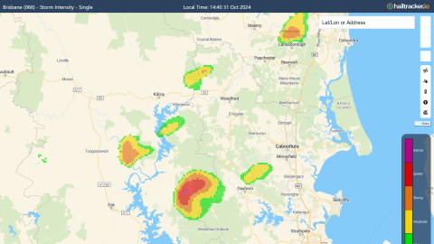
City of Moreton Bay has become the first local government in Queensland to integrate advanced thunderstorm tracking features from WeatherWatch into its Disaster Dashboard.
Recent unseasonal thunderstorm activity is serving as a timely reminder of the importance of staying informed with real-time weather updates.
Mayor Peter Flannery said the update is a significant step forward in keeping the community safe and informed during the upcoming severe weather season.
“In partnership with WeatherWatch, we’re proud to be the first Council to introduce real-time thunderstorm risk information into our Disaster Dashboard,” Mayor Flannery said.
“This new feature clearly shows which areas are most at risk from current thunderstorm activity, helping residents prepare for potential impacts.
“The system highlights severe thunderstorms and updates every five minutes using radar imagery from the Bureau of Meteorology's Mt Stapylton station in Brisbane.”
Local Disaster Management Group Chair and Division 10 Councillor Matthew Constance said the new feature ensured residents have the best information at their fingertips when it mattered most.
“Residents can now simply click on individual storm cells to see their severity and potential impacts at a glance,” he said.
“In a disaster, it’s vital to know where to turn for reliable information. We encourage everyone to monitor the Bureau of Meteorology’s website and app for official warnings alongside Council’s Disaster Dashboard for local updates on severe weather, road closures, power outages, evacuation centres and more.”
WeatherWatch Meteorologist and Managing Director Anthony Cornelius said having this information publicly available will help the community to plan and prepare.
"Our Storm Intensity mapping combines advanced three-dimensional radar analysis with atmospheric data to identify storms that display the telling signs of severe conditions,” Mr Cornelius said.
“Our goal is to make severe weather information accessible and easy to understand. Partnering with City of Moreton Bay puts information in the community’s hands, helping people make informed decisions and stay safe when storms strike.
“Like any weather analysis tool, it's not a one-size-fits-all solution, which is why we recommend using it alongside official weather warnings for the most complete picture."
The City of Moreton Bay Disaster Dashboard can be accessed at https://disaster.moretonbay.qld.gov.au/
To understand your risks and plan for severe weather season visit: https://www.moretonbay.qld.gov.au/Services/Disaster-Management
The Bureau of Meteorology (BOM) is Australia’s official source of weather warnings. For more information on weather warnings visit: https://www.bom.gov.au/