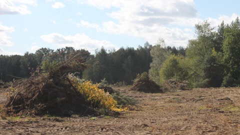
Clearing trees and vegetation on private property

You may need Council approval before clearing or cutting trees and vegetation on your property.
Protecting natural areas and wildlife habitats is important to Council and our communities. Preserving biodiversity is essential for supporting our local wildlife and ecosystems. This helps ensure they will be around for future generations to enjoy.
Before clearing or cutting any vegetation, you should contact Council. A Council officer will assess your property to ensure it can be cleared.
Vegetation clearing and lopping
Lopping a tree means cutting or pruning its branches. This cutting isn't severe enough to kill the tree. It also does not include removing the trunk.
Clearing means removing or damaging plants. This includes:
- cutting trees down
- ring-barking (cutting bark around a tree)
- pushing over or poisoning trees
- burning, flooding, or draining the area
- removing undergrowth or thinning vegetation.
Tree and vegetation regulations
Council's planning scheme and state legislation regulate clearing and lopping on public and private land. This includes local and national parks, as well as habitats for threatened species. It also covers areas of native vegetation and wildlife corridors. These environmental features and areas fall into two categories:
- Matters of Local Environment Significance
- Matters of State Environmental Significance.
Matters of Local Environmental Significance (MLES)
MLES are environmental areas important at a local level. They're any vegetation with biodiversity, cultural or heritage value. This includes but is not limited to:
- Habitat trees. Habitat trees are native trees with large canopies or structural hollows. They provide many native animals with places to live, breed, and seek shelter. Even old or dead trees can be a habitat tree as they can still provide important habitat for wildlife.
- Koala habitat trees. A koala habitat tree is a food tree used by koalas. Species common to Moreton Bay include gum, brush box, paperbark, bloodwood and myrtle trees.
- Non-juvenile koala habitat trees. A non-juvenile koala habitat tree offers both food and shelter for koalas. These trees help koalas travel through changed or developed areas.
MLES are managed through Council's planning scheme and environmental policies. Council considers these matters in decisions about land use or development. This protects local environmental areas from degradation.
Tree clearing or lopping without Council approval may be illegal.
Matters of State Environmental Significance (MSES)
MSES are environmental features or areas that have been identified as significant. This may be for biodiversity, ecosystems, water resources, or other ecological values at a state-wide scale. MSES are often established through state legislation, regulations, or planning policies. MSES areas include protected vegetation, wildlife habitats, and koala habitats.
- Category A: Vegetation that has been illegally cleared and must be restored.
- Category B: Native Vegetation that is mostly undisturbed and has not been cleared before.
- Category C: Native vegetation in an area that has not been cleared for at least 15 years.
- Category X: Vegetation that is not mapped as a Category A, Category B or Category C area.
Development or land use in MSES areas typically requires state-level assessment and approval. Certain protections apply to ensure these areas are not harmed.
Learn more in the Environmental areas and corridors planning scheme policy(PDF, 11MB).
How to identify high value areas and koala habitats
You are generally not allowed to clear or lop trees in a koala habitat or priority area without approval. To see if your property is in these areas, request a vegetation management report. The report will also show which categories of vegetation are on your property. You will need to provide the lot and plan number of your property. This can be found using my property lookup.
To see if your property is in a high value area, use Council's interactive overlay mapping. Enter your property's address and check 'Environmental Areas' in the Layer List panel.
You can also access koala habitat mapping through Queensland Globe. This is an interactive map that shows various spatial layers.
Building and development in koala habitat areas
As more land is developed, we must all take steps to protect the natural areas koalas rely on.
Thoughtful planning and design are key to koala conservation. It can help reduce the risks to koalas from development by keeping important habitat areas intact.
Doing so makes it easier for koalas to move safely through landscapes. It also includes managing potential dangers during construction.
Supporting koala safety and wellbeing helps ensure they survive and thrive for generations to come.
To learn more on how to reduce impacts during development, read the Koala-sensitive design guideline. It supports compliance with Queensland’s environmental planning policies. It also offers practical solutions for creating koala-friendly landscapes.