Mill Central will be home to the first full service university campus in the Moreton Bay Region and will provide a revitalised and active district centre for Petrie. The university will be supported and complemented by a vast range of uses and activities, including regional sporting facilities and health related opportunities.
Together, they will form an incubator for change and ignite new economic growth for the Moreton Bay Region by leveraging all it has to offer. Mill Central will become a highly attractive and vibrant destination, with a range of quality urban spaces hosting a mix of retail, commercial, residential, community and recreation uses, with a district centre to the west of the rail line and the neighbourhood hub to the east. Mill Central will be brought together by a highly embellished public realm that will include smart city technology, public art, and quality landscape treatment.
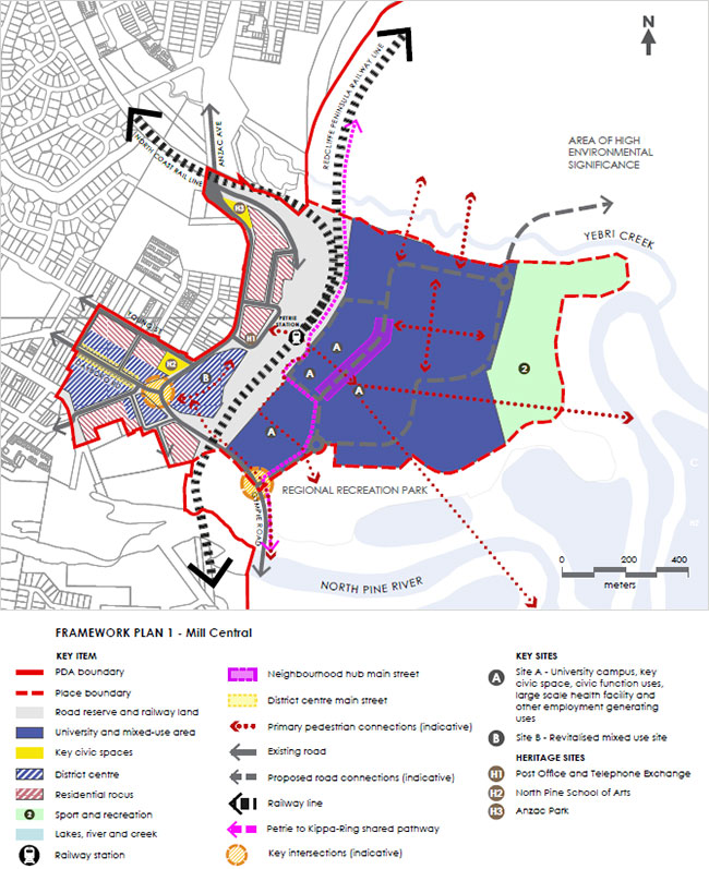
Key facts and figures
Land area
91.33 ha
Land uses
- The university and mixed-use area - USC Moreton Bay campus and associated activities, convenience retail and speciality stores, community buildings, mix of residential uses (including student accommodation), and commercial employment.
- District centre - enhance and increase the range and mix of businesses and commercial activities in the District Centre on the western side of the North Coast Rail Line, including offices and high end comparison and convenience retail. Revitalisation of the District Centre Main Street through the establishment of active uses adjoining the street.
- Residential focus - mix of residential uses (including student accommodation) in the form of medium and high density residential housing dwellings that incorporate home offices which enable commercialisation of home businesses, ‘start-ups’ and small to medium enterprise (e.g. 2-3 storeys) may establish in concentrated pockets around the fringes of Mill Central.
- Key Site A will comprise the university campus, a key civic space, a signature building suitable for civic function uses, a significant anchor facility (e.g. large scale health facility such as a hospital and specialist medical centre) in a signature building(s) and other employment generating commercial uses.
- Key Site B will comprise a signature development with an interesting and diverse range of uses and activities.
- Interim uses that promote activity and deliver amenity in the place including markets, pop ups and food vans to encourage start-up businesses and increase visitors to the place are expected.
Building height
- Key Sites A and B contain no maximum building height.
- For the remainder of Mill Central, generally buildings will be no greater than 27m high (8 storeys).
Infrastructure
- New roads through the University and mixed-use area to support development.
- New pedestrian connections over the rail line along the northern side of Gympie Road and an enhanced crossing near Petrie Railway Station.