Planned burns in Moreton Bay
Council conducts planned burns during low bushfire risk periods to:
- reduce available bushfire ground fuels
- minimise the risk and severity of bushfires
- reduce the threat to life and assets.
Council uses Bureau of Meteorology weather forecasts to determine suitable days to carry out a burn, which must adhere to permit conditions.
Protecting flora, fauna and habitats
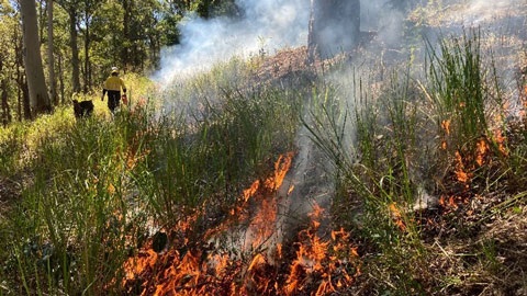
Initially, Council’s Fire Management team will conduct a site assessment of the proposed location. The assessment highlights flora and fauna that may need protecting. This process helps preserve native plants, animals, and habitats such as tree hollows, nests and dens, which may need preparation works.
Ignitions are carried out to allow them to move slowly at low intensity. This, plus raking around trees, helps crews protect any significant flora and fauna habitats.
A wildlife spotter is also on-site to monitor wildlife.
Notification of planned burns
Residents are notified through the planned burn schedule and area maps. Nearby residents who are signed up for MoretonAlert will get a text message or email. Council will also notify people living in properties adjoining a planned burn location by mail and signage.
Community safety and potential impacts of bushfire smoke
Residents in surrounding areas may notice smoke during and after the burn. Council recommends asthmatics and people sensitive to smoke stay indoors. Keeping windows and doors closed will reduce smoke in the home.
Secure pets and livestock, if necessary. Motorists in the area should drive to the conditions. People should avoid the site during and in the days following.
In an emergency call 000 (triple zero). For more information, contact Council.
Search for planned burns near you
This element requires javascript to be enabled.Please wait while we load your map...
Scheduled planned burns and area maps
More burns may occur during the year depending on weather and site conditions. Council will notify nearby residents if this happens.
| Suburb |
Location |
Burn area |
| Armstrong Creek
|
Alison Booker Court Reserve, Alison Booker Court |
Burn area map |
| Banksia Beach
|
Bribie Island Community Arts Centre, 191-193 Sunderland Drive |
Burn area map |
| Bellara
|
Verdoni Street Park, 328 Sunderland Drive |
Burn area map |
| Burpengary
|
Caboolture Region Environmental Education Centre, 150 Rowley Road |
Burn area map |
| Burpengary East
|
Buckley Road Park, 139 Buckley Road |
Burn area map |
| Caboolture
|
Scarborough Road Park, 59 Scarborough Road |
Burn area map |
| Cashmere
|
Wessling Close Park, 5 Ron Bischof Close |
Burn area map |
| Donnybrook
|
Toorbul Donnybrook Pony Club Grounds, 1100 + 1104b Pumicestone Road |
Burn area map |
| Mount Glorious
|
Harland Road Reserve (north section), Lot 36 Harland Road |
Burn area map |
| Ocean View
|
Dean Drive Reserve, 9 Dean Drive |
Burn area map |
| Samford Valley
|
Brian Burke Reserve, Woodview Street |
Burn area map |
| Samsonvale
|
Mount Samson Road, Road reserve between Basin Road and Winn Road |
Burn area map |
| Sandstone Point
|
Godwin Beach Reserve, 317A Bestmann Road |
Burn area map |
| Toorbul
|
Otto Street Gravel Reserve, 6-40 Otto Road |
Burn area map |
| Upper Caboolture
|
Sheep Station Creek Conservation Park West, 302 Williamson Road (MacGinley Road Park) |
Burn area map |
| Upper Caboolture
|
Sheep Station Creek Conservation Park North, 302 Williamson Road (Tinney Road Park) |
Burn area map |
| Woodford
|
Kauri Court Park, 46-76 Ironbark Drive |
Burn area map |